
Météo-France Rain radar Network
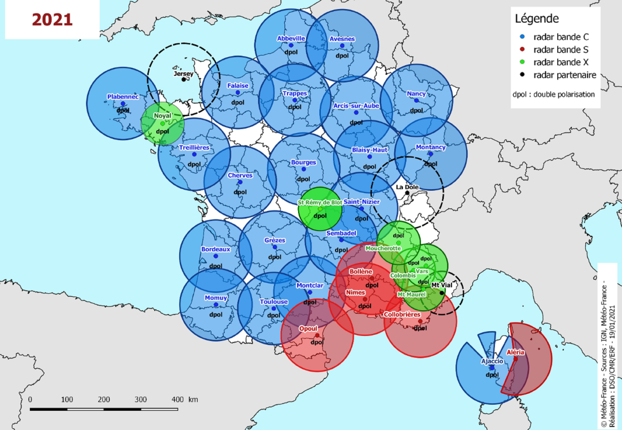
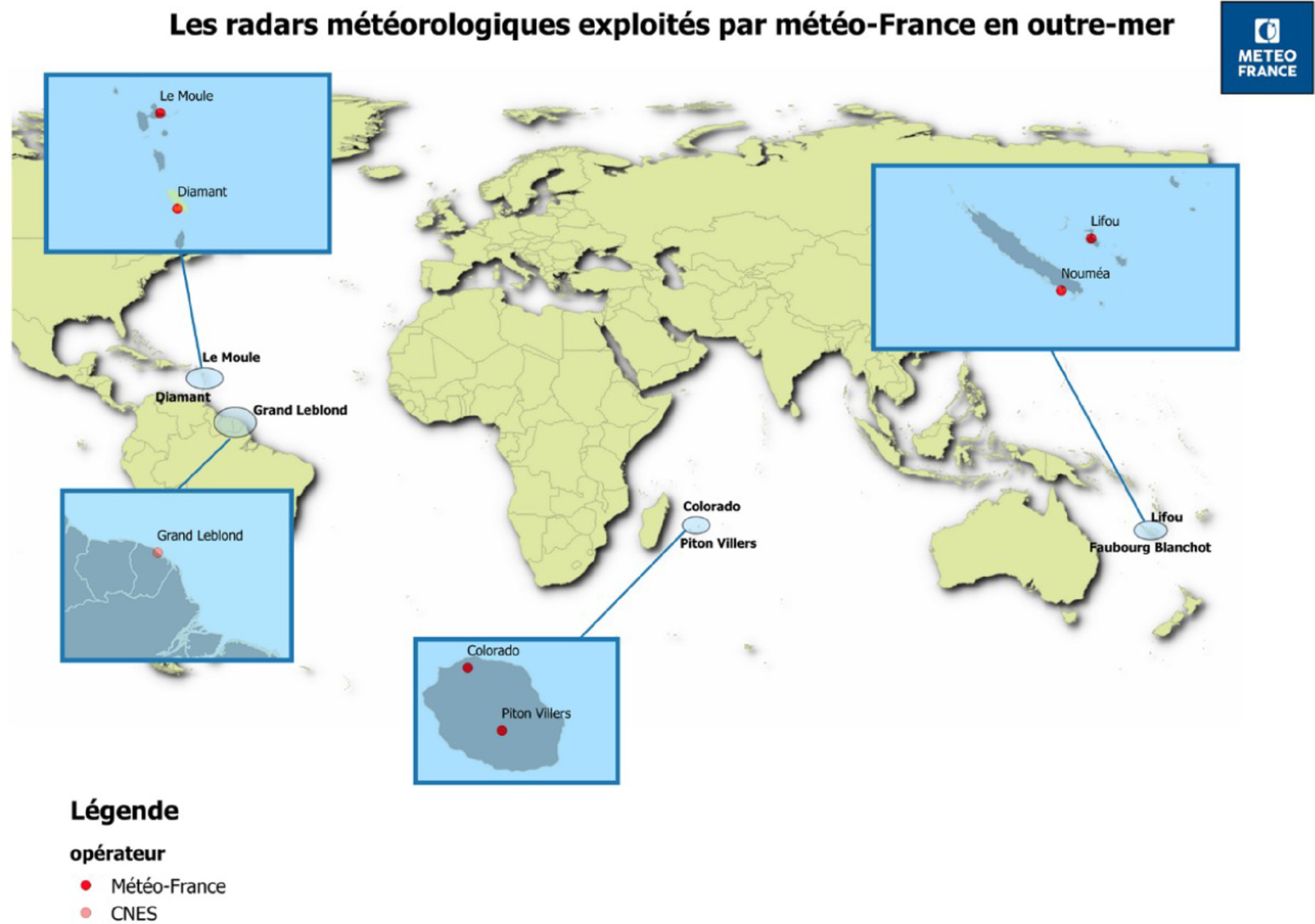
AERIS provides access to radar data from the Météo-France French operational network in mainland France and overseas.
The radar data is made up of four products:
- 5min Water Wave Cumulative Mosaic
- COMEPHORE Hourly Water Level Mosaic
- Raw Single-Polarisation Radar Data – PAG
- Raw Radial Data Double-Polarisation – PAM
AERIS manages the conversion chain from Météo-France products in BUFR format to the NetCDF format widely used in the Atmosphere community. Recent products since 2017 have been converted and are available for download. The conversion of historical data since the 1990s is currently being processed.
AERIS also manages requests and access to products via a dedicated website (see Data access section).
Description of products
Mosaics are composite images of precipitation areas and their accumulations every 5 minutes.
Cumulative Mosaic 5min Water Blade
The NetCDF “5min Cumulative Mosaic” product is a 5-minute product, available for the four domains: Metropolitan France, Reunion Island, the West Indies and New Caledonia.
Each file contains the following two mosaic parameters:
The quality code in % (QUALITY variable): Its values are coded between 0 (unusable) and 100 (excellent). For a given pixel, the quality code assigned to the mosaic is the best of the individual quality codes of the radars covering the pixel.
The 5-minute water level in 1/100mm (ACRR variable):
This is an estimate of the cumulative rainfall in 5 minutes, obtained by composing the individual 5-minute water depths of the radars in the Météo-France network.
The individual radar waves from the different radars are combined, taking into account the respective quality codes of the pixels from the different radars.
The cloud classification from the satellite imagery and the reflectivity texture are used to generate a probability of rain (PP). The rain probability product is used to filter out clear air and residual clutter in the water mosaic.
COMEPHORE Hourly Water Wave Mosaic
COMEPHORE (COmbinaison en vue de la Meilleure Estimation de la Precipitation HOraiRE) is an hourly reanalysis of precipitation by merging radar and rain gauge data, covering mainland France.
The AERIS “COMEPHORE Mosaic” product is a NETCDF product available for mainland France. It is monthly and groups together all the hourly COMEPHORE mosaics for the month. The data is masked beyond approximately 30 km from coasts and borders.
It contains 3 parameters:
- The reanalysis of the cumulative hourly water level in 1/10mm (RR variable)
- The uncertainty in the cumulative hourly water level in 1/10 mm (variable ERR)
- A radar qualification code (QUALIF variable)
Raw Single-Polarisation Radar Data – PAG
The PAG type files concern Doppler parameters. Here are the main characteristics of the product:
- Granularity: 15-minute cycle / 1 radar
- Availability: All radars in mainland France and overseas
- Resolution: 0.5° azimuth x 1000m and 720 radials x 256 gates per revolution
- Parameters: Horizontal reflectivity, Standard deviation, Radial speed
Raw Dual-Polarisation Radial Data – PAM
PAM files contain polarimetric parameters. Here are the main characteristics of the product:
- Granularity: 15-minute cycle / 1 radar
- Availability: Dual-polarisation radars in mainland France and the French overseas territories
- Resolution: 0.5° azimuth x 240m and 720 radials x 1066 gates per revolution
- Parameters: Horizontal reflectivity, Correlation, Differential reflectivity and Differential phase
Data Access
The products are described in the AERIS Catalogue
Requests for access to data should be made on the dedicated website :https://radarsmf.aeris-data.fr
Contact
radarsmf@sedoo.fr