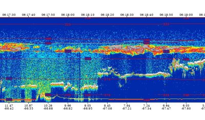
The eruption of Piton de la Fournaise observed by the web platform VolcPlume
The Piton de la Fournaise, reaching an altitude of 2,632 metres, is the active volcano on the island of Reunion in the Indian Ocean. Piton de la Fournaise is one […]


Highlights
The Piton de la Fournaise, reaching an altitude of 2,632 metres, is the active volcano on the island of Reunion in the Indian Ocean. Piton de la Fournaise is one […]

Highlights
On 14 January, the Tonga-Hunga Ha’apai undersea volcano erupted and caused a tsunami. It flooded the coasts of Japan, the United States and killed two people in Peru. The eruption […]
Highlights
The EGU geosciences conference, taking place May 3–8 in Vienna, recently released its full program. Here is a brief overview of the presentations and sessions featuring scientists from the AERIS […]
AERIS/ICARE
The CALIPSO (Cloud-Aerosol Lidar and Infrared Pathfinder Satellite Observation) space mission is a joint mission between CNES and NASA and was dedicated to measuring the vertical distributions and optical and […]
Highlights
AERIS is continuously working to enhance the services it provides to the atmospheric science community. In light of the substantial increase in expected data volumes, we need your input to […]
AERIS/ICARE
AERIS/ICARE, in collaboration with the companies SPASCIA and HYGEOS is participating in a project led by EumetSAT (Cloud Optimised Use Cases) of a proof of concept for porting a processing algorithm […]
AERIS/ICARE
AERIS/ICARE, in collaboration with the companies SPASCIA and HYGEOS is participating in a project led by EumetSAT (Cloud Optimised Use Cases) of a proof of concept for porting a processing algorithm […]

AERIS/ESPRI
AERIS provides new updates for IASI products, ensuring the continuity and consistency of data from Metop satellites. These updates concern carbon monoxide (CO), ozone (O3) and peroxyacetate nitrate (PAN). CO/O3 […]
AERIS/SEDOO
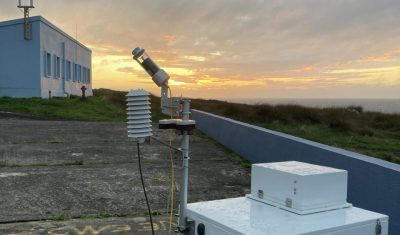
Scientific context: Measurements of total CO₂ and CH₄ columns from the ground using solar-pointing FTIR remote sensingserve three purposes: The project aims to archive and promote the measurements of total […]
AERIS/ESPRI
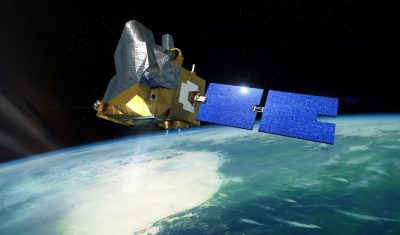
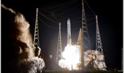
On the night of 12 to 13 August, Ariane 6’s second commercial mission launched the European observation satellite MetOp-SG-A1 (Second Generation A1) into orbit for the European Organisation for the […]
AERIS/ICARE
Following the July 25th launch, MicroCarb observed the Earth for the first time on August 28th. We are very excited to present a first observation acquired over the Amazon. This […]