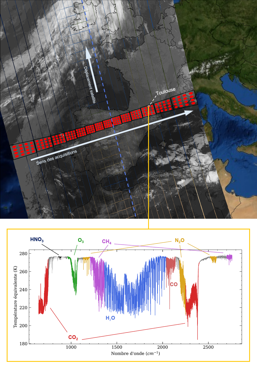
IASI-NG
Launched into orbit in August 2025 aboard EUMETSAT’s European meteorological satellite Metop-SG A-1, the new atmospheric sounding instrument designed by CNES has just delivered its first data, confirming that it […]

Launched into orbit in August 2025 aboard EUMETSAT’s European meteorological satellite Metop-SG A-1, the new atmospheric sounding instrument designed by CNES has just delivered its first data, confirming that it […]
Scientific context C²OMODO (Convective Core Observations through MicrOwave Derivatives in the trOpics) is a CNES space project, a tandem of radiometers that will be launched in March 2030, as part […]

Scientific background Clouds cover about 70% of the Earth’s surface and play a dominant role in the energy and water cycle of our planet. Only satellite observations provide a continuous […]

Developed by CNES (Centre National d’Etudes Spatiales) in partnership with Eumetsat (EUropean organisation for the exploitation of METeorological SATellites), the IASI (Infrared Atmospheric Sounding Interferometer) instrument was designed for operational meteorology and for monitoring atmospheric chemistry and climate. IASI is a thermal infrared Fourier transform spectrometer that provides radiance spectra and derived atmospheric variables to feed operational weather forecasting centers, the Copernicus Services and the scientific community.

Over past years CNRM has developed with support from AERIS/ICARE the AERUS-GEO suite of Aerosols and Surface properties products (https://www.icare.univ-lille.fr/projects/user-driven-projects/aerus-geo/). Initially aimed at providing a daily averaged Aerosol Optical Depth (AOD) from SEVIRI sensors aboard the MSG satelliteseries, the project is now about to provide retrievals of aerosol properties at 15-min intervals thanks to the new i-AERUS-GEO algorithm (currently under validation).

The scientific objectives of the Microcarb mission are to provide the scientific community with the information (vertical CO2 concentration columns) to monitor the surface fluxes of CO2 between land, atmosphere, oceans and vegetation. These objectives are similar to those of the NASA-JPL OCO-2 mission. A particularity of Microcarb is to achieve this objective with a small instrument that can be embarked on a Myriad-type microsatellite platform. If the Microcarb experiment proves to be successful, this could lead to a long-term operational system for continuous monitoring of carbon flows. A constellation would make it possible to achieve higher spatial and temporal resolution for determining the fluxes, which remains a desirable objective.

The aim of the mission is to provide the global measurements of aerosols and clouds needed to achieve a better understanding of their role in climate, and to improve our ability to predict long-term climate change and seasonal or inter-annual variations. CALIPSO and CloudSat are highly complementary and together provide 3-D perspectives of how clouds and aerosols form, evolve, and affect weather and climate. They fly in formation with other satellites in the A-train constellation to enable an even greater understanding of our climate system from the broad array of sensors on these other spacecraft. CALIPSO and CloudSat are in orbit around the Earth at an altitude of 705 km, with a nominal inclination of approximately 98.2 degrees. They were launched together on April 2006 for an initial duration of 3 years. However, due to their good performance, their missions have been gradually extended until 2022.

Megha-Tropiques is a space mission jointly managed by the space agencies CNES and ISRO. This mission is designed to study the convective systems of the atmosphere and more particularly the analysis of the water cycle through the transport and distribution of water vapor, the life cycle of convective systems and energy exchanges in the equatorial belt. The tropical zones are those where the most important energy exchanges occur: radiative exchanges, latent heat exchanges, transport of constituents and energy through dynamic processes. The challenge is therefore to increase knowledge of hydrological and energy processes in the tropics and their influence on the global circulation of the atmosphere, that the oceans, and climatic variations.

POLDER (POLarization and Directionality of the Earth’s Reflectances) instrument analyses the intensity and direction of light reflected by the Earth and its atmosphere, as well as its polarization, a physical characteristic describing how waves propagate. Such measurements reveal some interesting properties of clouds and aerosols, thereby telling us more about how they affect climate. Designed and developed by CNES, in close collaboration with the LOA atmospheric optics laboratory in Lille, the POLDER instrument is mainly dedicated to the study the of the clouds and aerosols properties, but it also provides valuable information on the directionality of terrestrial reflectances and on the ocean colour. It has been the first space instrument to provide global and systematic spectral, directional and polarization measurements of radiation reflected from the Earth and atmosphere.

Several satellites and space-based instruments were launched in the 1990s-2000 to observe the ozone layer in the stratosphere. More generally, the objective was to better understand the chemistry of the middle stratosphere (stratosphere, mesosphere) and to validate chemistry-transport models to reproduce and predict the ozone hole. These instruments are generally spectrometers covering various spectral ranges, from microwave to ultraviolet. They record atmospheric absorption or emission spectra (level 1) from which inverse models can be used to produce columns or vertical profiles of atmospheric constituent concentrations (level 2) with very high accuracy.
| Name | Description | Start date | End date | Data access |
|---|---|---|---|---|
| IASI-CInfrared Atmospheric Sounding Interferometer | IASI-C is the third model of the IASI instrument series developed by CNES in cooperation with the European Organisation for the Exploitation of Meteorological Satellites (Eumetsat). Its two main missions are operational meteorology and atmospheric chemistry. It is a Fourier transform infrared spectrometer that provides luminance spectra of the atmosphere and derived atmospheric variables. IASI-C is on board the Eumetsat Metop-C satellite. | 08/04/2019 | - | |
| IASI-BInfrared Atmospheric Sounding Interferometer | IASI-B is the second model of the IASI instrument series developed by CNES in cooperation with the European Organisation for the Exploitation of Meteorological Satellites (Eumetsat). Its two main missions are operational meteorology and atmospheric chemistry. It is a Fourier transform infrared spectrometer that provides luminance spectra of the atmosphere and derived atmospheric variables. IASI-B is on board the Eumetsat Metop-B satellite. | 22/01/2013 | - | |
| CloudSat | CloudSat is a NASA satellite. It is studying clouds in detail to better characterize the role they play in regulating Earth’s climate. It is providing a global survey of the vertical structure and overlap of cloud systems and their liquid and ice-water contents. | 31/10/2006 | - | |
| CALIPSOCloud-Aerosol Lidar and Infrared Pathfinder Satellite Observation | Calipso is a joint Earth science mission between NASA and CNES dedicated to the measure of the vertical distributions as well as of the optical and physical properties of aerosols and clouds in the atmosphere, which influence the Earth’s radiation balance. For this purpose, it combines an active lidar instrument with passive infrared and visible imagers. | 30/10/2006 | - | |
| SMRSub-millimeter Microwave Radiometer | The Swedish SMR instrument, developed jointly with France and Finland, was launched on 20 February 2001 on board the Swedish mini-satellite ODIN . This microwave receiver is operational in the […] | 20/02/2001 | 29/09/2022 | |
| SCARABSCAnner for RAdiation Budget | SCARAB is a scientific instrument on-board the French-Indian satellite Megha-Tropiques dedicated to the study of the Earth’s radiative budget. It is a CNES/CNRS instrument, heritage of the first 2 SCARAB […] | 03/11/2011 | 14/03/2022 | |
| SAPHIRSounder for Probing Vertical Profiles of Humidity | SAPHIR is a scientific instrument on-board the French-Indian satellite Megha-Tropiques mainly dedicated to the probing of vertical profiles of humidity in the intertropical belt. It was designed and developed by CNES. The SAPHIR instrument is a 6 channel passive microwave humidity sounder. Its channels are located close to the 183.31 GHz water vapour absorption line. Its spatial resolution is 10 km at nadir and its swath width is 1700 km. | 03/11/2011 | 14/03/2022 | |
| IASI-AInfrared Atmospheric Sounding Interferometer | IASI-A is the first model of the IASI instrument series developed by CNES in cooperation with the European Organisation for the Exploitation of Meteorological Satellites (Eumetsat). Its two main missions […] | 24/05/2007 | 15/10/2021 | |
| Parasol | PARASOL is a CNES satellite of the Myriade series, flying within the A-Train and embarking the 3rd POLDER (POLarization and Directionality of the Earth’s Reflectances) instrument. The aim of its mission is to characterise the radiative properties of clouds and aerosols by making the best use of the complementarity with the other instruments of the A-train constellation such as the CERES and MODIS radiometers on-board the AQUA satellite, the CALIPSO lidar and the CloudSat radar. In addition to these sensors, PARASOL carries out polarised and multi-directional reflectance measurements of the Earth/atmosphere system. | 04/03/2005 | 11/10/2013 | |
| MADRASMicrowave Analysis and Detection of Rain and Atmospheric Structures | MADRAS is a scientific instrument on-board the French-Indian satellite Megha-Tropiques mainly dedicated to the study of precipitation in the intertropical belt. It was developed jointly by the space agencies ISRO and CNES. MADRAS is a conical scanning microwave radiometer with 9 channels. The rotation speed is about 25 rpm. It operates in the 18.7 GHz - 157 GHz frequency band. Its swath width is 1700 km. | 15/10/2011 | 26/01/2013 | |
| POAMPolar Ozone and Aerosol Measurement | The POAM instruments were developed by the US Naval Research Laboratory (NRL) to measure the vertical distribution in the atmosphere of ozone, water vapour and nitrogen dioxide (NO2), as well […] | 01/09/1996 | 31/05/2006 | |
| SAGE IIStratospheric Aerosol and Gas Experiment | The SAGE II instrument was developed by NASA to provide the scientific community with a global and long-term description of the distribution of aerosols, ozone, water vapour and NO2. It […] | 01/10/1984 | 31/08/2005 | |
| POLDER-2Polarization and Directionality of the Earth's Reflectances | POLDER-2 is the 2nd instrument of the CNES POLDER series. It contributed to the continuation of the French-Japanese space cooperation initiated with POLDER-1 and was embarked on-board the ADEOS-2 satellite (JAXA). Quite identical to POLDER-1, POLDER-2's main goal is to analyze the properties of clouds and aerosols and to provide information on the directionality of terrestrial reflectances and on the ocean color. | 14/12/2002 | 24/10/2003 | |
| ILASImproved Limb Atmospheric Photometer | The ILAS instrument, developed by the Japan Environment Agency (NIES), was launched on the ADEOS 1 satellite on 17 August 1996. It was a visible/infrared spectrometer, recording atmospheric absorption spectra […] | 17/08/1996 | 30/06/1997 | |
| Polder-1Polarization and Directionality of the Earth's Reflectances | POLDER-1 is the first instrument of the CNES POLDER series. It was the result of the first Franco-Japanese space cooperation and was embarked on the ADEOS satellite of NASDA (now JAXA). Designed and developed by CNES, in close collaboration with the LOA atmospheric optics laboratory in Lille, the POLDER instrument is mainly dedicated to the study of the clouds and aerosols properties, but it also provides valuable information on the directionality of terrestrial reflectances and on the ocean colour. It has been the first space instrument to provide global and systematic spectral, directional and polarization measurements of radiation reflected from the Earth and atmosphere. | 30/10/1996 | 29/06/1997 |