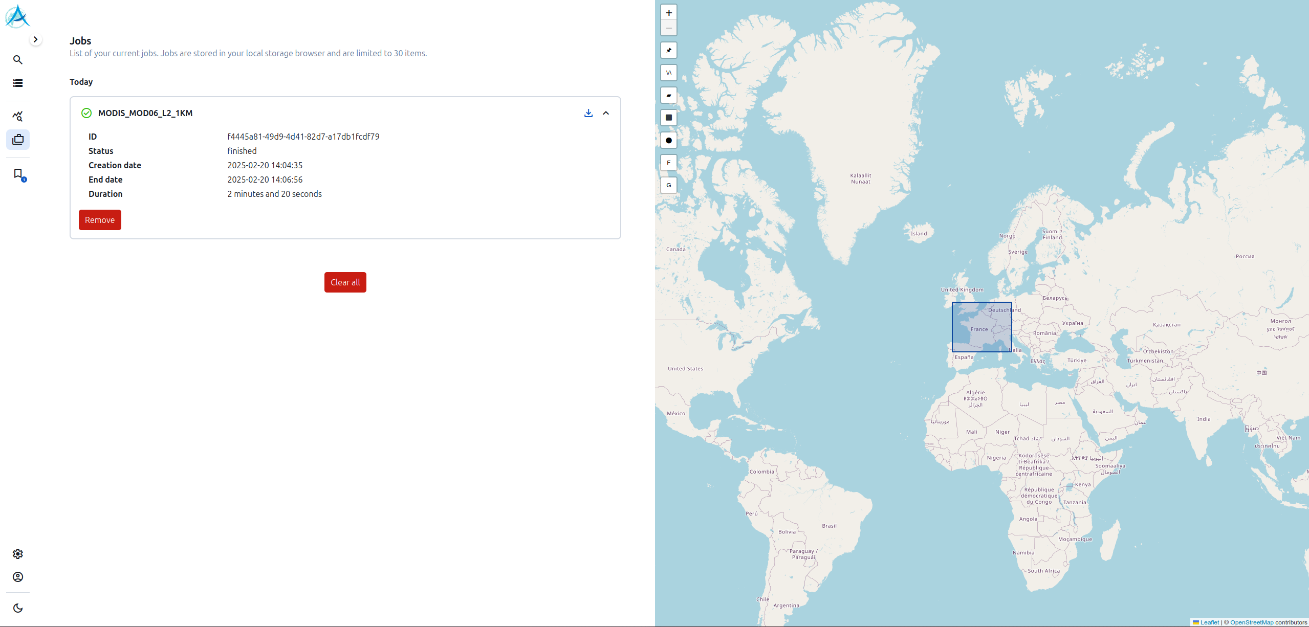
Tools and software

SAFRAN

SAFRAN (developped at Meteo-France/CNRM) is a mesoscale analysis of near surface meteorological variables over France, at 8km for the spatial resolution and hourly for the temporal frequency and suitable for […]

Stations Hub

The AERIS/ICARE data center has developed a data visualization platform for the various ground-based platforms. The stations with data visualization are : Access to the Station Hub is via ICARE’s […]

Volcplume

Initially developed at the LOA, Laboratoire d’Optique Atmosphérique de Lille (LOA), within the framework of the VOLCPLUME project financed by the French National Research Agency (ANR-15-CE04-0003) and coordinated by Marie Boichu, the […]

TAPAS SERVICE

TAPAS is a free online service for the astronomical community, allowing the user to access simulated atmospheric transmission for specific observing conditions (description available in Bertaux et al., 2014). It […]

MIMOSA

The project The MIMOSA model (Modélisation Isentrope du transport Méso-échelle de l’Ozone Stratosphérique par Advection) has been developed at Service d’Aéronomie in the frame of the European Union project METRO […]

ReOBS

The “ReOBS” project aims to create a multi-parameter dataset with advanced quality control in a format that can be easily exploited by the scientific community for the study and understanding […]

4A/OP

The 4A/OP software package is the operational version of the fast and accurate radiative transfer model 4A (Automatized Atmospheric Absorption Atlas), developed, maintained and validated at LMD. The 4A high […]

REPROBUS

The project REPROBUS (Reactive Processes Ruling the Ozone Budget in the Stratosphere) is a Chemical Transport Model that describes the stratospheric chemistry by means of 55 chemical species and 147 […]

SOFT-IO version 1.0

Others

NameDescriptionStart dateEnd dateData access
MISVAMonitoring and forecast of IntraSeasonal Variability over AfricaMISVA – Monitoring and forecast of IntraSeasonal Variability over Africa – is a joint research/operational collaboration between Meteo-France and the West African weather forecasting services: ANACIM (Senegal), Mali Meteo, ANAM […]01/01/2011-link
BAMEDBalloons over the Mediterranean seaBAMED (Balloons over the Mediterranean sea) is a model providing trajectory forecasts for BPLB (Boundary Layer Pressurized Balloons) over the Mediterranean sea.---
GarrlicThe GARRLiC algorithm provides micro-physical and optical aerosol properties, inverting simultaneously sun/sky radiometer and lidar ground-based observations. This synergistic approach can provide column-integrated parameters, like the particle volume size distribution, […]--link
GIRAFEreGIonal ReAl time Fire plumEsPresentation GIRAFE is a software which provides forecasts of plumes trajectories. Trajectories are calculated using lagrangian dispertion model FLEXPART and ECMWF meteorological fields. GIRAFE uses fire detections of MODIS satellite […]---

Search